Photographing earth from the stratosphere Part I
How I took images of the earth from 100,000 feet for less than $1,000

I. Background
When I was 19, I committed myself to eventually launching a commercial space company. How that decision came about is a post for another time, but that underlying factor is the motivation for this project. My long-term obsession with space naturally bleeds over into my spare time.
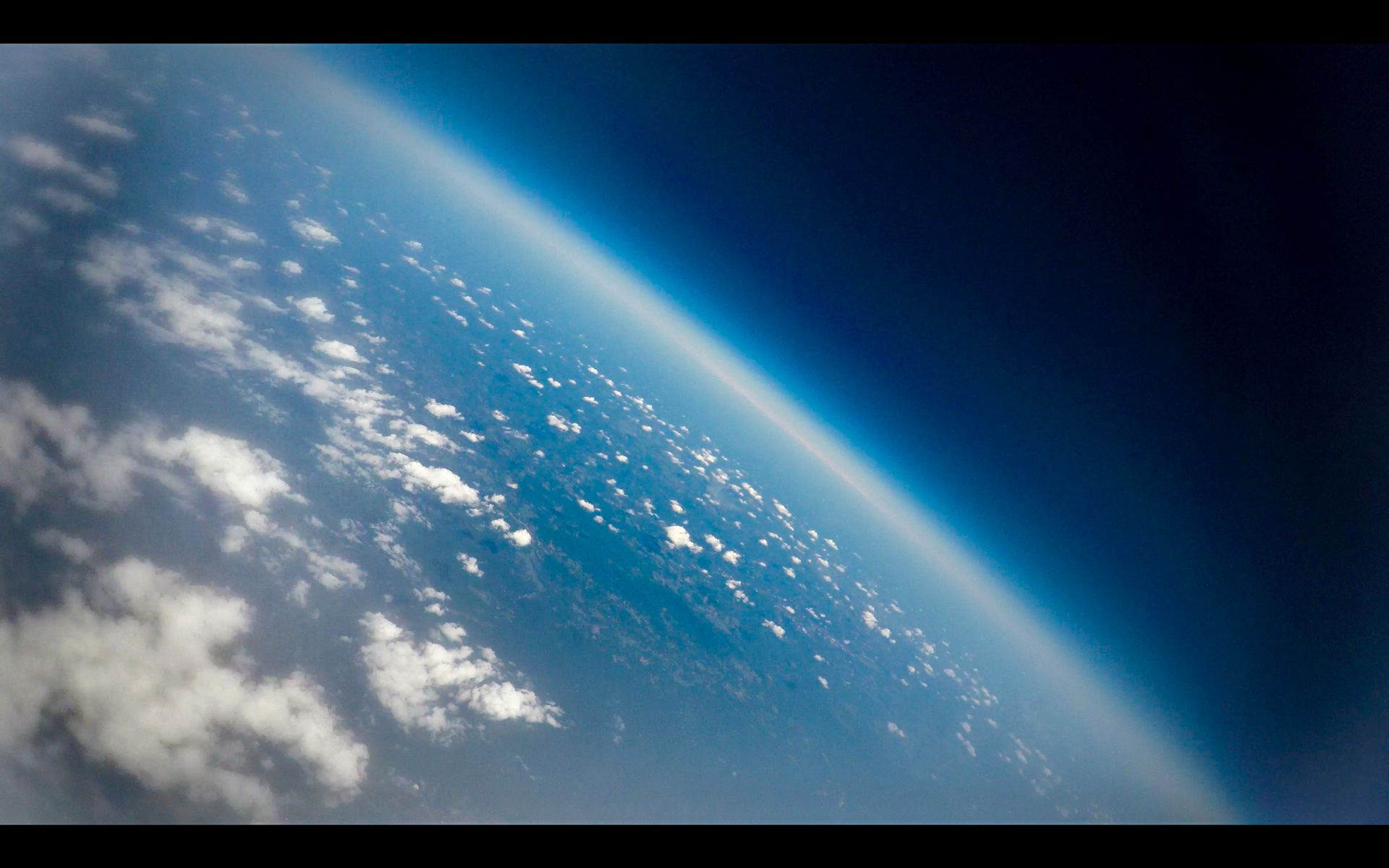
At the age of 20, I read about a group of MIT students who were able to get images of the blackness of space and curvature of the earth by launching a high-altitude weather balloon (HAB) into the stratosphere. It was hard to believe how relatively inexpensive the project was – under $1000. No need to wait for commercial space tourism. No need to compete to become an astronaut. All that was required was the research, a few friends, time, and $500-700 worth of gear.
I knew I had to try this one day.
Three years later, after I wrapped up grad school and started a new job in DC, I began planning.
It wasn’t until I was 27, however, that the launch actually took place.
Why did it take so long?
- During my first couple of years in DC, I worked many nights and weekends to help grow a startup from five employees to 60+ while teaching myself graphic, front-end, and UX design. This left little time for serious side projects. I didn’t even take a vacation until well into my third year on the job (not recommended).
- I wanted to do my due diligence. From studying the FAA regs to learning about mistakes made by other HAB teams, I wanted to do all I could to prevent injuring a person or property. I also didn’t want my project on the news or to find myself in trouble with the law.
- The weather was often uncooperative. Even on clear days, the direction and intensity of the wind often led to poor flight path predictions – e.g. the expected flight path traveled over airports, major cities, or an extremely long distance.
II. Project overview
The goal was pretty straight-forward – launch a high-altitude balloon to record footage of the earth from the stratosphere and then recover the payload.
For this first build, I decided not to include a flight computer or do any high-altitude science experiments. The basics – a successful launch and recovery – were my priorities.
The rest of this post covers my build process and how I selected the launch site. A second post details the actual launch and recovery.
III. Research phase
Over the past three years, I devoured hundreds of blog articles and and YouTube videos related to high-altitude ballooning.
There’s actually a lot of great material out there…
Like tales of balloons lost at sea. How-to guides for building SMS tracking systems. And, of course, loads of cool videos…
IV. Build phase
After doing some preliminary research, I kicked off the build process by focusing on how not to harm anyone or break the law.
Seemed like the right thing to do.
IV.I FAA regulations
The FAA regs are actually pretty straight-forward and easy to meet.
PART 101—MOORED BALLOONS, KITES, AMATEUR ROCKETS AND UNMANNED FREE BALLOONS
- Payload must be under 6lbs
- Break strength of rope must be < 50lbs
- If the balloon is up for more than 2hrs, you must alert the FAA. This is called a "floater."
Since I’m based in DC, I also had to travel 100 miles to get out of restricted airspace.
To make it clear that I followed the letter of the law, I printed out the regs and taped them on the side of the payload.
IV.II Payload components

Harris Teeter cooler
Pretty standard $10 cooler. Easy to cut holes in and then seal against water.
SPOT GEN 3 GPS Tracker
The GPS was obviously one of the most important parts of the payload – second only to the launch vehicle (cooler). It also tied the GoPro for most expensive part. $150 for the Spot + $150/year for the online tracking service.
To ensure a clear and consistent GPS signal, I had to fashion a crude gimbal-like contraption out of photo frame wire. This ensured that the Spot always pointed toward the sky, no matter which way the payload rotated.
GoPro Hero 4 Black
I bought the GoPro refurbished online, but I still felt conflicted about launching such an expensive device without guarantee of recovery. Not a millionaire yet.
IV.III Lift system
Balloon
Based on my research, I went with the Aether Industries 600g 20 ft diameter professional weather balloon.
To figure out how much helium I needed, I used the recommendations and reference table on the Aether site: “It is recommended to have a total lift weight of 2 lb. (1 kg) plus the total weight of the payload in order to control the ascent speed.”

Parachute
After debating whether or not I wanted to create my own, I ended up just purchasing a 5ft chute from Rocketman.
Kite string
Connecting the Balloon to the parachute and the payload is the tether. To achieve the FAA’s required < 50lb break strength, I decided to use kite string.
Latex Gloves
The oil from your skin can actually cause the balloon at a lower-than-desired altitude. To avoid this issue, our team wore latex gloves when handling the balloon.
Cable ties
To securely close the mouth of the balloon, I used cable ties.
V. Launch criteria and flight simulation
Picking a launch site wasn’t easy. The site had to meet some pretty strict criteria:
- 100 miles outside of DC
- Within a day’s drive to/from my apartment
- Not close to any airports or urban areas
- Positioned such that the wind would not carry the balloon toward any airport, major urban area, or large body of water – e.g. Chesapeake Bay or Atlantic Ocean.
Thankfully, there are some great free tools available to help with this step.
Tool #1: Google Maps.
I first used Google Maps to scout out potential launch sites outside the 100 mile radius and ensure no airports were nearby.
Tool #2: Flight simulator.
After finding a possible launch location using Google Maps, I plugged the coordinates, along with some other key data, into a HAB flight simulator to see where the balloon might end up. This step was critical. A couple of scenarios with strong winds had the balloon ending up in downtown DC, downtown Baltimore, and near a military facility.
The final flight plan avoided all of these obstacles.

Check out my second post for the story of the launch and recovery.